U.S. Geological Survey, M 6.8 - 7 km SSE of Longbranch, Washington, https://earthquake.usgs.gov/earthquakes/eventpage/uw10530748/executive, Accessed: June 31, 2022.
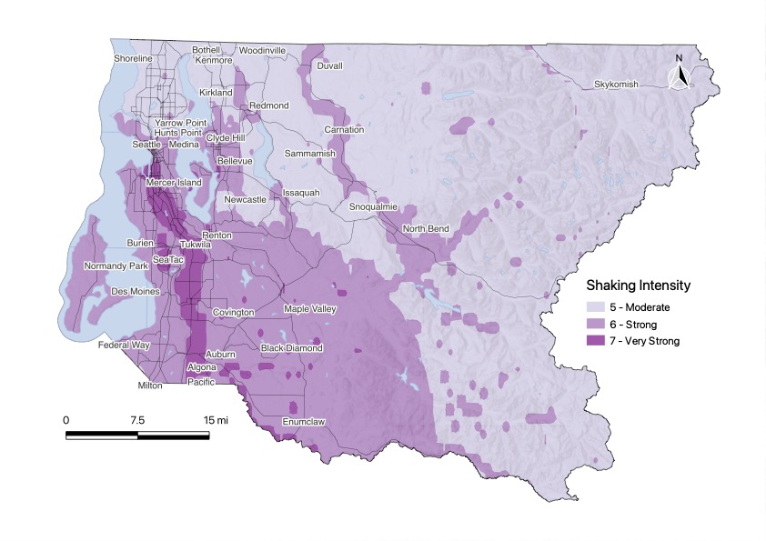
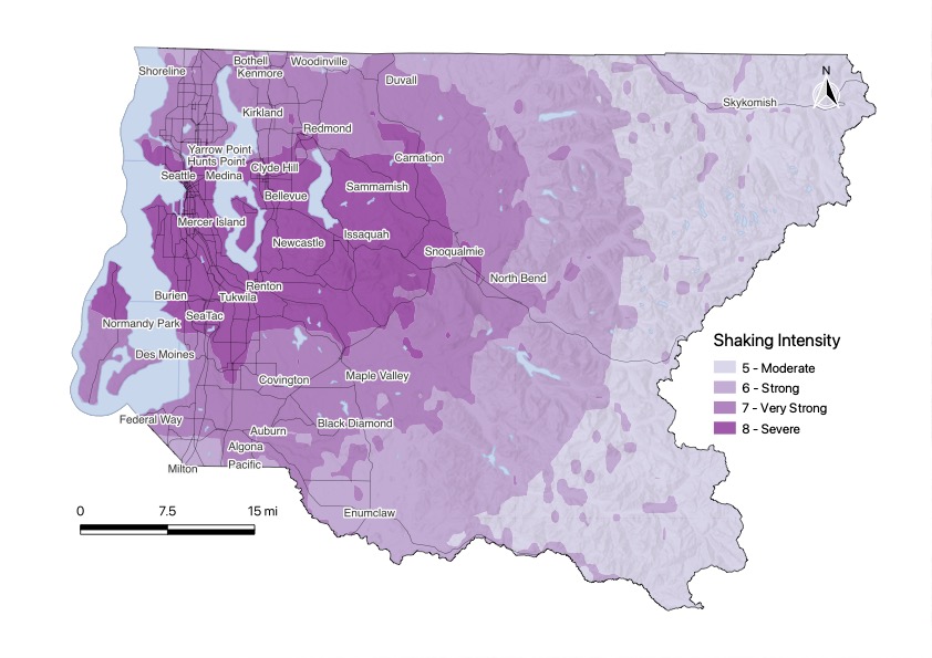
Petersen, M.D., Moschetti, M.P., Powers, P.M., Mueller, C.S., Haller, K.M., Frankel, A.D., Zeng, Yuehua, Rezaeian, Sanaz, Harmsen, S.C., Boyd, O.S., Field, Ned, Chen, Rui, Rukstales, K.S., Luco, Nico, Wheeler, R.L., Williams, R.A., and Olsen, A.H. (2014). Documentation for the 2014 update of the United States national seismic hazard maps: U.S. Geological Survey Open-File Report 2014–1091. p. 243. http://dx.doi.org/10.3133/ofr20141091, Accessed: June 31, 2022.
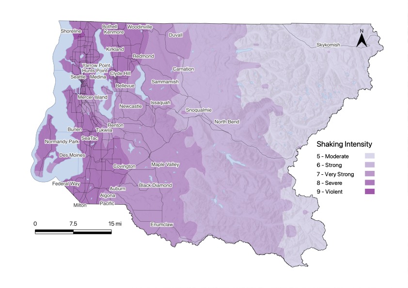
Wirth, E. A., Grant, A., Marafi, N. A., and Frankel, A. D. (2021). Ensemble ShakeMaps for magnitude 9 earthquakes on the Cascadia subduction zone, Seismological Research Letters, https://doi.org/10.1785/0220200240, Accessed: June 31, 2022.
Washington Geological Survey. (2017). Seismic scenario catalog—GIS data, August 2017: Washington Geological Survey, version 1.0, originally created March 2010. https://www.dnr.wa.gov/programs-and-services/geology/publications-and-data/gis-data-and-databases, Accessed: June 31, 2022.
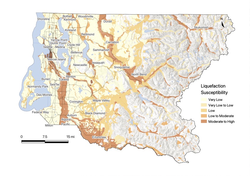
Palmer, Stephen P.; Magsino, Sammantha L.; Bilderback, Eric L.; Poelstra, James L.; Folger, Derek S.; Niggemann, Rebecca A. (2007). Liquefaction susceptibility and site class maps of Washington State, by county: Washington Division of Geology and Earth Resources Open File Report 2004-20. https://www.dnr.wa.gov/programs-and-services/geology/publications-and-data/gis-data-and-databases, Accessed: June 31, 2022.
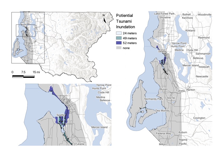
Washington Geological Survey. (2022). Tsunami hazard--GIS data: Washington Geological Survey Digital Data Series 22, version 1.4, February 2022. Previously released January 2022. https://fortress.wa.gov/dnr/geologydata/publications/data_download/ger_portal_tsunami_hazard.zip, Accessed: June 31, 2022.
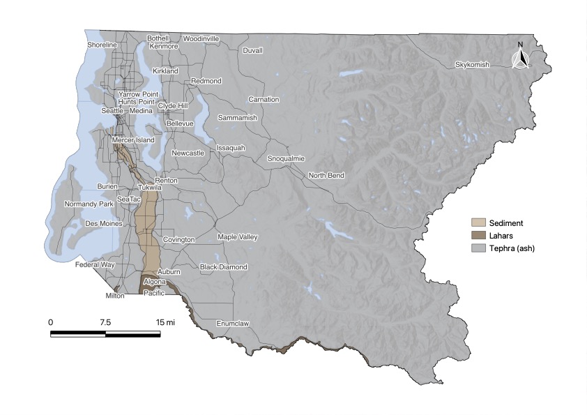
Washington Geological Survey. (2016). Simplified volcanic hazards, adapted from U.S. Geological Survey--GIS data: Washington Division of Geology and Earth Resources, version 1.0, May, 2016. https://www.dnr.wa.gov/programs-and-services/geology/publications-and-data/gis-data-and-databases, Accessed: June 31, 2022.
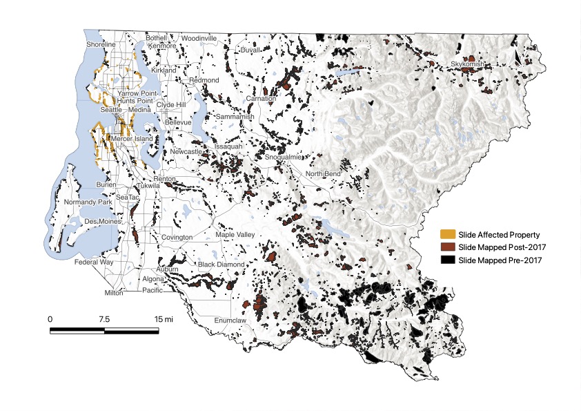
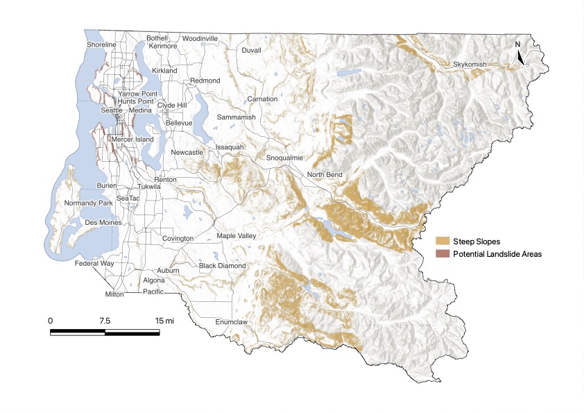
Washington Geological Survey. (2020). Landslide Compilation--GIS data, February 2020: Washington Geological Survey Digital Data Series 12, version 5.2, previously released January, 2019. https://fortress.wa.gov/dnr/geologydata/publications/data_download/ger_portal_landslide_compilation.zip, Accessed: June 31, 2022.
Washington Geological Survey. (2020). Landslide protocol inventory mapping--GIS data, February, 2020: Washington Geological Survey Digital Data Series 19, version 2.0, previously released January, 2019. https://fortress.wa.gov/dnr/geologydata/publications/data_download/ger_portal_landslide_inventory.zip, Accessed: June 31, 2022.
King County GIS. (2016). Potential steep slope hazard areas: King County, King County, WA. https://gis-kingcounty.opendata.arcgis.com/datasets/kingcounty::potential-steep-slope-hazard-areas-steep-slope-hazard-area/about, Accessed: June 31, 2022.
City of Seattle. (2012). Potential Landslide Areas: City of Seattle, Seattle, WA. https://data.seattle.gov/dataset/Potential-Landslide-Areas/qbkw-5p37, Accessed: June 31, 2022.
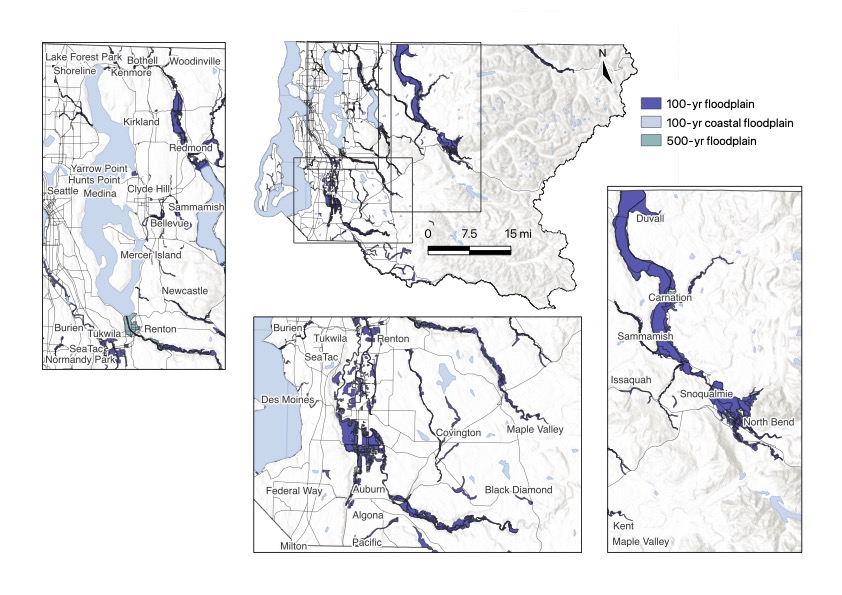
King County GIS. (2020). FEMA 500 Year Floodplain in King County: King County, King County, WA. https://gis-kingcounty.opendata.arcgis.com/datasets/kingcounty::fema-500-year-floodplain-in-king-county-fema-floodplain-500yr-area/about, Accessed: June 31, 2022.
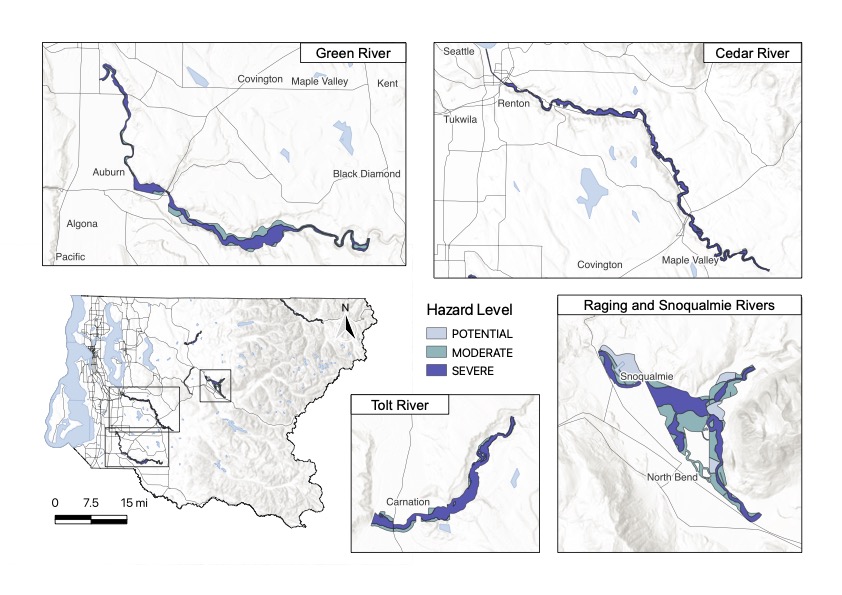
King County GIS. (2005). Channel Migration Areas in King County: King County, King County, WA. https://gis-kingcounty.opendata.arcgis.com/datasets/kingcounty::channel-migration-areas-chnlmigr-area/about, Accessed: June 31, 2022.
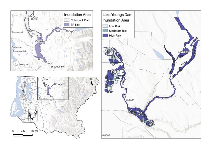
King County GIS. (2013). Culmback and South Fork Tolt River, Dam Inundation Hazus Update. West Consultants Inc. (2011). Lake Youngs Dam Break Analysis.
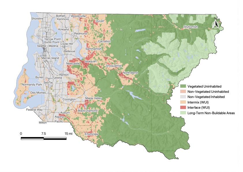
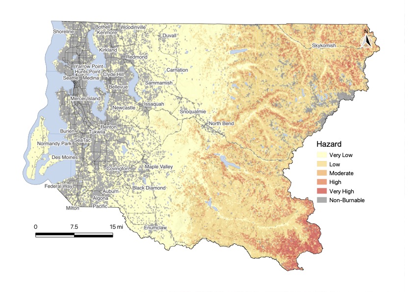
Washington Department of Natural Resources. (2020). Washington Wildland Urban Interface (WUI): Washington Department of Natural Resources, Wildfire Division. Zones and Metadata, Accessed: June 31, 2022.
Dillon, G.K., Gilbertson-Day, J.W. (2020). Wildfire Hazard Potential for the United States (270-m), version 2020. 3rd Edition. Fort Collins, CO: Forest Service Research Data Archive. https://doi.org/10.2737/RDS-2015-0047-3, Accessed: June 31, 2022.
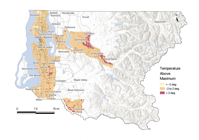
CAPA Strategies, 2020, Seattle and King County Heat Watch Report, https://osf.io/nkgx9?view_only=d304510b100f421883b4c6d85518edf9.
Have questions? View the About page or email the Hazard Ready creators for more information.